How to find us
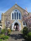
The church building is situated in Sidcup Hill. It is set back from the road, so you will probably see our graveyard first. There is a pedestrian crossing right outside the church.
View Foots Cray Baptist Church in a larger map
On Foot
From Sidcup town centre it is a 10 minute walk. Head east along Sidcup High Street and then go down Sidcup Hill until you see the church on your left.
By Car
If you have a SatNav, try the postcode DA14 6JS and house number 137. The following tips may help:
1. Find the A20
From the West (eg Central London), take the A2/A20 which divides at New Cross. Take the A20 towards Lewisham. You should eventually see “Sidcup” on signposts on the A20.
From the East (eg M25), leave at junction 3 for the A20 towards London.
2. From the A20
You need the A224 signposted Foots Cray at Crittal’s Corner. Follow the road north past B&Q and then a Coca Cola/Schweppes plant on your right until you reach the traffic lights. Turn left. This is Sidcup Hill and you should soon see the church on your right by a pedestrian crossing.
The church has a car park, but if it is full or being used for another meeting, do not use Sidcup Hill. You should find some space in Middleton Avenue opposite the church or in Caerleon Close to the west next to the church. There are other streets a little further away.
By Train
Our nearest station is Sidcup, which is 30 minute walk so you may prefer to catch the buses 51, 233 or 492. For times visit http://www.nationalrail.co.uk/.
By Bus
There is a bus stop close to the church for services 51, 321, 233, 492 or R11. For bus information visit Transport for London. TfL refers to the stop as “Middleton Avenue/Sidcup Hill”
Grid references
51° 25.224′ N, 0° 6.906′ E
Ordnance Survey TQ 471711
- Sidcup Hill
- Sidcup
- Kent
- DA14 6JS
07566 208117
Email Us